
Sai Wan & Ham Tin: The Sai Kung Trail That Ends at a Beach
Photo by joekzy on Reddit
Sai Wan & Ham Tin: The Sai Kung Trail That Ends at a Beach
Difficulty: Moderate Time: 3 to 4 hours Distance: 10 to 12km
The Sai Wan Hong Kong hike is MacLehose Trail Stage 2 — a coastal walk through the eastern edge of Sai Kung Country Park that ends at Ham Tin beach, one of the most remote and cleanest stretches of sand in the territory. The route takes you along clifftops above the South China Sea, through two small seaside hamlets that feel like they belong to a different era of Hong Kong, and down to a beach most visitors never reach because getting there requires actual effort.
That effort is the point. Ham Tin beach is not on the way to anywhere. You arrive on foot or by boat, and the absence of any other access is exactly what keeps it as it is — turquoise water, coarse yellow sand, a cluster of fishing shacks converted into simple cafes, and a view of the peninsula that makes it difficult to believe you are in a city of 7 million people.
This trail appears in Iconic Hikes Hong Kong. The book captures what makes it distinctive. This post covers how to get there — which is a genuine question worth answering properly, because the logistics trip up a lot of people who want to do this walk.
The Walk: Sai Wan to Ham Tin

Photo by AllTrails
MacLehose Trail Stage 2 runs from Pak Tam Au (a mountain pass on the Sai Kung peninsula) east along the coast to Long Ke Wan, but the section most visitors do is the shorter coastal loop from Sai Wan village to Ham Tin beach — a distance of approximately 5 to 6km one way.
The trail starts at Sai Wan Pavilion and follows the coastline south and east. The path is wide and well marked through the first section, with open clifftop walking above steep sea cliffs. The water below is clear enough that on calm days you can see the bottom. The rock formations along this stretch of coast are columnar joint basalt — hexagonal columns of volcanic rock that stack like compressed honeycomb along the cliff face. The same geology appears at Sai Kung's Sharp Island and at Cape D'Aguilar further west, but nowhere more dramatically than here.
After about 90 minutes the trail descends to Sai Wan hamlet — a small settlement of about 20 houses on a sheltered cove, some occupied year round, some used as weekend retreats. There is a small shop selling drinks and instant noodles. It is worth a pause.
From Sai Wan hamlet, the trail continues east to Ham Tin beach — another 30 to 40 minutes along the coast. The final descent to the beach is steep. The cafe at Ham Tin has been operating for decades under various configurations and typically offers cold drinks, instant noodles, and in summer, basic camping gear rental. Do not arrive expecting a restaurant — bring your own food if you want a proper lunch.
How to Get to Sai Wan: The Complete Transport Guide
This is where most guides fall short. Getting to Sai Wan Pavilion — the official trailhead — requires three stages of transport from urban Hong Kong, and the last leg (taxi from Sai Kung to Sai Wan Pavilion) is not available at all hours or in all seasons. Plan this carefully.
Stage 1: MTR to Sai Kung Town

Photo by Mingle Place
There are two main MTR starting points for Sai Kung, depending on where you are coming from.
Option A — via Diamond Hill MTR (recommended for most visitors): Take any MTR line to Diamond Hill station, Exit C2. From the bus stops on Lung Poon Street, board KMB bus 92 (destination: Sai Kung). This is an air-conditioned double-decker that runs approximately every 10 to 15 minutes during daytime hours. The journey takes about 35 to 40 minutes, passing through Clearwater Bay Road before descending into Sai Kung town. Alight at the Sai Kung Bus Terminus — the end of the route.
Option B — via Hang Hau MTR (faster from the Tseung Kwan O area): Take the Tseung Kwan O Line to Hang Hau station, Exit B1. From the bus terminus outside the exit, board green minibus 101M (destination: Sai Kung Town). The minibus runs frequently and takes approximately 20 minutes. Alight at Sai Kung town centre waterfront.
Option C — via Wong Tai Sin MTR: Take any MTR line to Wong Tai Sin station. Board KMB bus 1A (destination: Sai Kung). Journey time approximately 45 to 50 minutes. This route is longer but useful if you are connecting from Kowloon without easy access to Diamond Hill.
Stage 2: Sai Kung Town to Pak Tam Chung (optional)
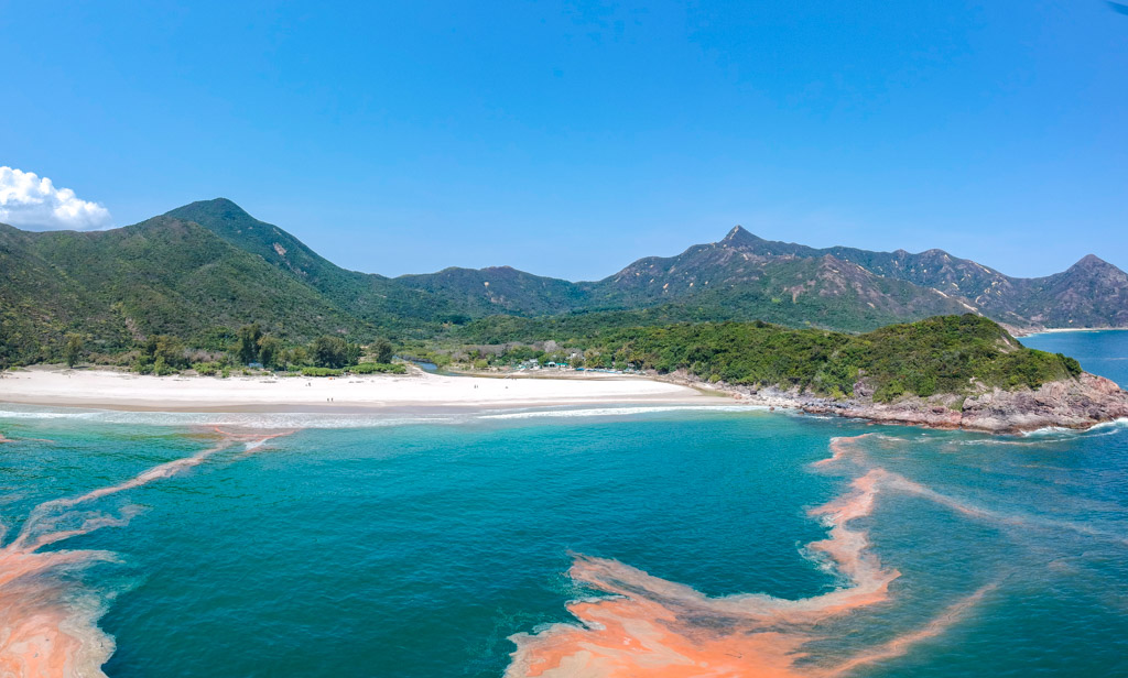
Photo by Laugh Travel Eat
If you want to start the walk from the western end of Stage 2 at Pak Tam Au, rather than at Sai Wan Pavilion, from Sai Kung town board bus 94 (destination: Wong Shek Pier). This bus runs along the main Sai Kung Peninsula road and stops at Pak Tam Chung — the gateway to the Sai Kung Country Park interior. From Pak Tam Chung you can access both Stage 2 (heading east toward Sai Wan) and the MacLehose Trail staging points further in. Bus 94 runs a limited schedule — check the KMB timetable carefully, as there are gaps of 30 to 60 minutes between services. On weekends it is more frequent.
Stage 3: Sai Kung Town to Sai Wan Pavilion (Taxi)
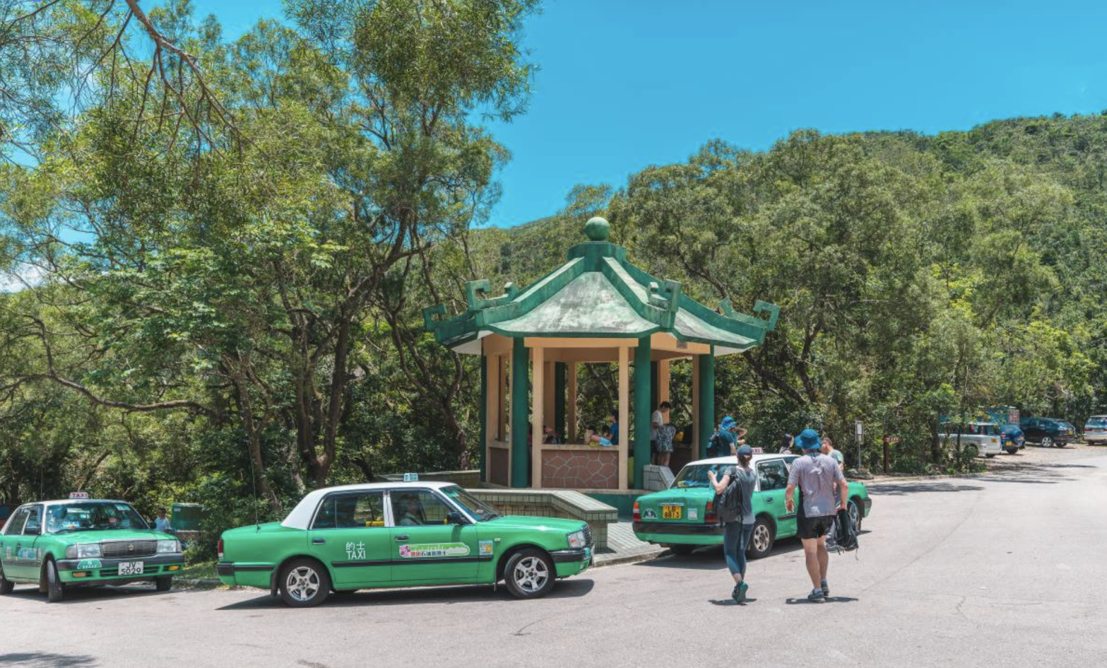
Photo by thingstodoinhk.com
From Sai Kung town, the direct route to Sai Wan Pavilion is by taxi. This is not accessible by public bus. The taxi ride takes approximately 20 minutes and costs roughly HKD 80 to 120 depending on traffic and whether you use the metered rate or negotiate. Taxis wait near the Sai Kung town waterfront — look for the red New Territories taxis rather than urban taxis (which are not licensed to operate in rural NT areas).
Tell the driver: "Sai Wan Pavilion" (西灣亭, Sai1 Waan1 Ting4). On weekday mornings the taxi queue is short. On weekend mornings in summer there can be a wait of 10 to 20 minutes.
Important: do not confuse Sai Wan Pavilion with "Sai Wan" — there is also a Sai Wan at the western tip of Hong Kong Island. Be clear with the driver you want Sai Wan Pavilion in Sai Kung.
How to Return: The Boat from Ham Tin
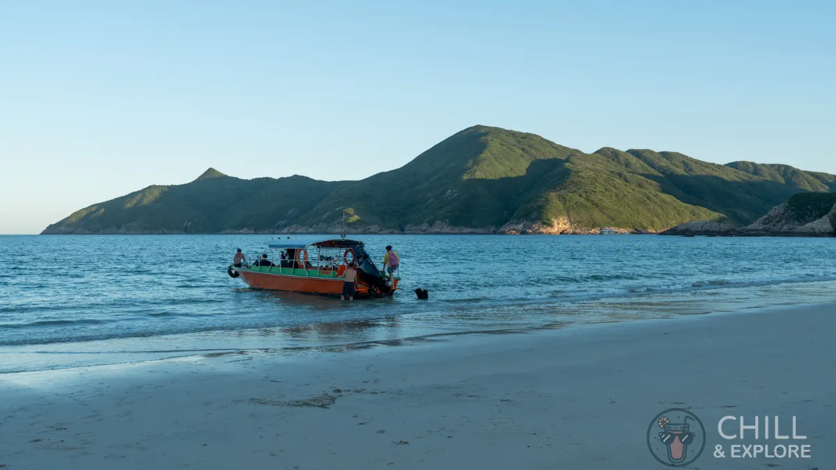
Photo by Chill & Explore
This is the best part of the logistics. From Ham Tin beach, you do not have to walk back the way you came. Kaito (small traditional ferries) run from Ham Tin Wan to Sai Kung pier on weekends and public holidays during the hiking season. The journey takes approximately 30 to 40 minutes across open water and past the islands of the inner Sai Kung archipelago.
The kaito service operates informally — boats depart when full or on request. In summer the service typically runs between approximately 10am and 6pm on weekends, with the last boat before dark. Do not count on a fixed schedule. Confirm with the cafe operator at Ham Tin when you arrive that the boats are running that day before you plan your return around them.
The fare is approximately HKD 80 to 100 per person, paid in cash on the boat. Bring cash — there is no card payment option on the kaito.
If you prefer to walk back, retrace the trail to Sai Wan Pavilion and take a taxi back to Sai Kung. Do not attempt to walk to a bus-accessible road directly from Ham Tin — there is no direct route without significant off-trail navigation.
When to Go
October to December is the best period: clear skies, low humidity, cool walking temperatures, and calm seas that make the kaito return comfortable. The coastal views are at their sharpest in November when the air is dry.
The walk is beautiful in the wet season (May to September) but the heat and humidity on the exposed clifftops are demanding. Start before 8am if you go in summer, carry at least 2 litres of water per person, and check the Hong Kong Observatory for thunderstorm warnings. The exposed ridgeline is not safe in lightning.
Avoid weekends in summer if you want the beach to yourself. Ham Tin is genuinely remote enough that it never gets as crowded as the accessible beaches, but peak summer Saturdays still see significant foot traffic from overnight campers.
What to Bring
- Water — minimum 2 litres per person. There are no reliable water sources on the trail between Sai Wan Pavilion and Ham Tin.
- Cash — for the taxi (HKD 80 to 120), the kaito return (HKD 80 to 100), and any food/drinks at the Ham Tin cafe.
- Hiking shoes with grip. The descent to Ham Tin is steep and can be muddy after rain.
- Sun protection — the clifftop sections are fully exposed.
- A fully charged phone with the trail downloaded offline on AllTrails or a similar app. Signal can be intermittent on the eastern peninsula.
- A light layer for the boat return — sea breezes can be cool even in summer.
Sai Wan / Ham Tin Trail (MacLehose Trail Stage 2) is one of the 26 trails in Iconic Hikes Hong Kong. The book gives each trail the cultural weight it deserves — not a directions guide, but a portrait of the landscape itself.
→ Get the book. → Browse all trail prints.Combining Sai Wan with Other Sai Kung Trails
If you are making the journey to Sai Kung, it is worth knowing what else is nearby. Sharp Island (Kiu Tsui Chau) is accessible by kaito from Sai Kung pier — a completely different kind of walk on a small island famous for its tombolo (a sand bar that connects two landmasses at low tide). The geological features are among the most photogenic in the entire Hong Kong UNESCO Global Geopark. This is also a trail in Iconic Hikes Hong Kong and a natural pairing with Sai Wan if you are spending a full day in the area.
The Pak Tam Chung visitor centre near the country park entrance is worth a short stop — the AFCD runs an exhibition there covering the Sai Kung Country Park ecology and MacLehose Trail history. It helps contextualise the landscape you are walking through, and it is free.
Sai Wan Hong Kong Hike: Common Questions
Is there public transport directly to Sai Wan Pavilion?
No. Sai Wan Pavilion is accessible only by taxi from Sai Kung town. The taxi journey takes about 20 minutes and costs roughly HKD 80 to 120. There is no public bus service to the pavilion itself. Plan this leg in advance, especially if you are visiting on a weekend when taxis are busier.
Can you camp at Ham Tin beach?
Yes. Ham Tin Wan has a designated AFCD campsite. You need to register in advance through the AFCD camping registration system. Pitches are limited and in demand on summer weekends. Camping here and walking out the next morning is one of the best ways to experience the beach — you have it almost entirely to yourself at dawn.
Does the kaito (boat) run in bad weather?
No. Kaito operators will not run in strong winds or rough seas, and will cancel if a typhoon signal is raised. In summer, check the weather before you commit to the boat return. Have a contingency plan — walking back to Sai Wan Pavilion via the trail is your main alternative.
How difficult is the trail compared to Dragon's Back?
Sai Wan to Ham Tin is longer and more demanding than Dragon's Back — the total distance is greater, the terrain is more varied, and there are steep sections both descending to Sai Wan hamlet and to Ham Tin beach. Both are classified as moderate. The key difference is the length and the remoteness: Dragon's Back has bus access at both ends; Sai Wan requires more planning and carries you further from the urban infrastructure. See our Dragon's Back vs The Peak comparison for a sense of difficulty benchmarks.
Is it worth doing in winter?
Yes — winter (November to February) is excellent for this walk. The air is clear, the humidity is low, and the coast is at its most photogenic. The kaito still runs on weekends. Ham Tin beach is virtually empty on a weekday in December. If there is one season to prioritise for this trail, it is winter.
More from UpKow
- The complete guide to hiking in Hong Kong
- The best hikes in Hong Kong
- Easy hikes in Hong Kong for beginners
- Dragon's Back: Hong Kong's most iconic coastal trail
- How to get to the Peak, Hong Kong — every option explained
- 5 must-do hikes in Hong Kong: a 5 day itinerary
- The best Hong Kong gifts for hikers
- 9 things that surprise first time hikers in Hong Kong
- 5 Hong Kong hikes you can finish before breakfast
- Summer hiking in Hong Kong: trails, timing, and typhoon rules
- Lion Rock Hong Kong: the trail behind the symbol
- The best waterfall hikes in Hong Kong
- Dragon's Back vs The Peak: which Hong Kong trail should you do?
- Bride's Pool: the Hong Kong trail where the city becomes a rainforest
- Hong Kong hikes near MTR stations: 6 trails you can reach in 30 minutes