
Hong Kong Hikes Near MTR Stations: 6 Trails You Can Reach in 30 Minutes
photo by Expedia
Hong Kong Hikes Near MTR Stations: 6 Trails You Can Reach in 30 Minutes
One of the persistent myths about hiking in Hong Kong is that it requires a car, a Kowloon minibus negotiated in Cantonese, or a friend who has done it before. None of that is true. The MTR gets you surprisingly close to some of the best trails in the city — and in every case, a bus or minibus covers the last stretch. Hong Kong hikes near MTR stations are not a compromise. In several cases they are the best hikes in the territory.
What follows is a practical guide. For each trail you get the MTR station, the exit number, the onward bus or minibus, the journey time, and what you are walking into when you get there. These are trails from Iconic Hikes Hong Kong — the book gives each of them their full due. This post gives you the logistics to get there.
1. Dragon's Back — Shau Kei Wan MTR
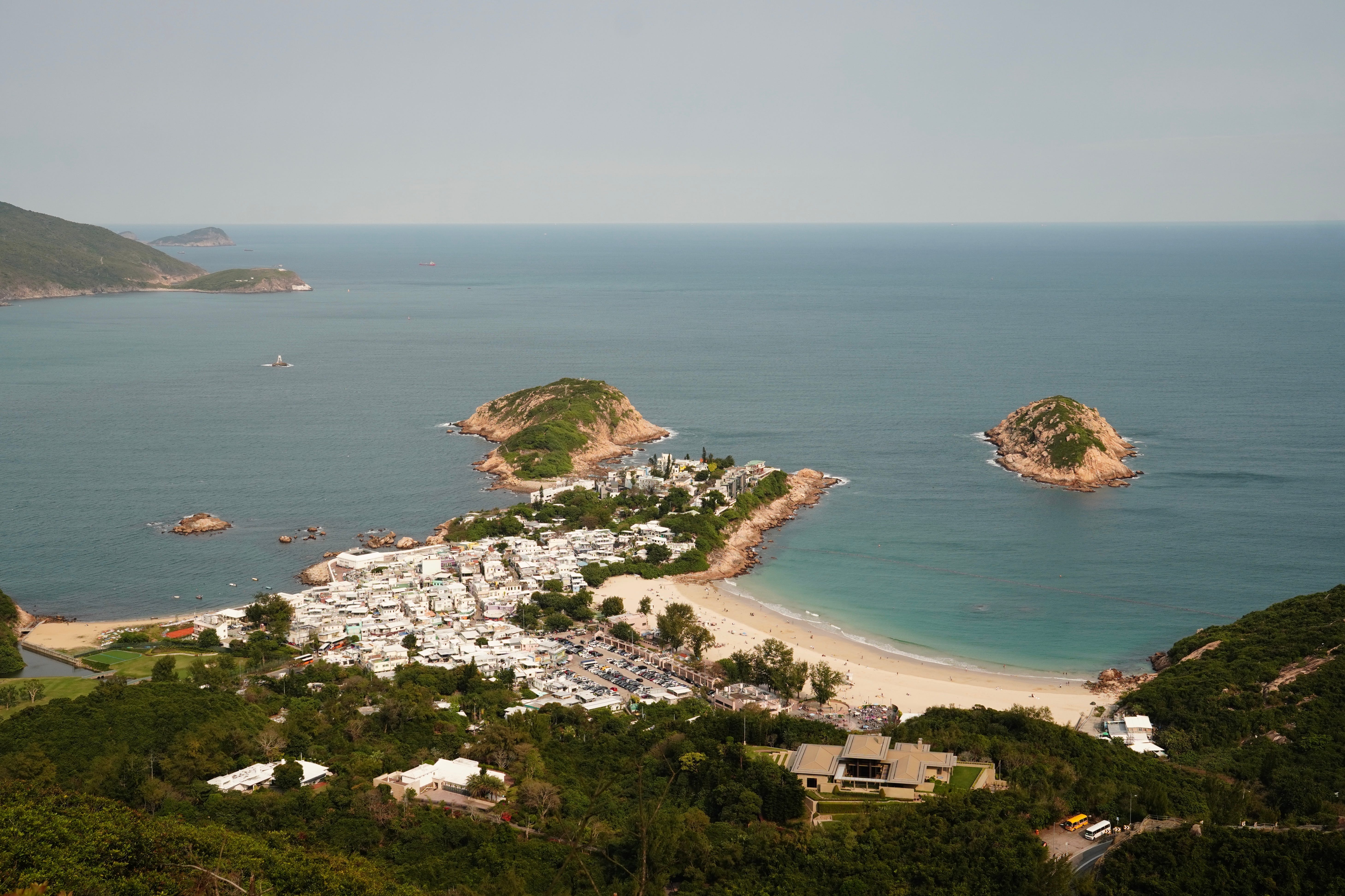
Photo by The Everyday Travellers
MTR to trailhead: about 25 minutes | Difficulty: Moderate
Dragon's Back sits on the southeastern edge of Hong Kong Island in Shek O Country Park, and it is consistently ranked among the best urban hikes in Asia. The ridge trail gives you open views of the Shek O headland, the Sai Wan peninsula, and on clear days the outer islands to the south. The descent into Shek O village adds a natural endpoint — lunch, a cold drink, and a bus or taxi back.
Exact directions: Take the Island Line to Shau Kei Wan MTR, Exit A3. Turn left out of the exit and walk along Shau Kei Wan Road toward the bus terminus under the flyover — about a 3 minute walk. Board bus 9 (destination: Shek O). Buy your Octopus fare on board. The bus winds up through the hills and drops you at To Tei Wan — the last stop before the descent to Shek O — which is the Dragon's Back trailhead. Journey time on the bus: approximately 20 minutes. The trailhead is clearly signed from the bus stop.
Return: walk down to Shek O village (30 to 40 minutes) and catch bus 9 back to Shau Kei Wan, or take a taxi from the village.
→ The Dragon's Back art print — see it here.
2. Lion Rock — Wong Tai Sin MTR

Photo by ForSomethingMore
MTR to trailhead: about 20 minutes | Difficulty: Moderate to Strenuous
Lion Rock stands at 495 metres above sea level on the boundary between Kowloon and the New Territories, and its silhouette — a crouching lion, unmistakable from across the urban basin — has been part of Hong Kong's visual vocabulary since long before the 1972 RTHK documentary made "Lion Rock Spirit" a phrase. The scramble to the top is rewarding in the specific way that views you have earned always are.
Exact directions: Take any MTR line to Wong Tai Sin station, Exit B3. From the exit, walk along Lung Cheung Road eastward for about 5 minutes toward the bus stops. Board green minibus 18M from the stop on Lung Cheung Road, heading toward Lion Rock Country Park. The minibus takes approximately 10 to 15 minutes and drops you near Temple Hill Fat Jong Temple, which is the start of the main Lion Rock ascent trail. From the Fat Jong Temple drop-off, the trailhead is signed and begins immediately up the hill.
Alternatively, from Kowloon Tong MTR Exit C, walk along Waterloo Road and pick up minibus 18M from the Kowloon Tong stop — a slightly different routing that adds a few minutes to the journey but works well if you are connecting from the East Rail Line.
Return: descend the same route or continue to Sha Tin Pass, from which bus 82K runs to Sha Tin MTR (Ma On Shan Line). Check the MTR system map to plan your return connection.
See our full guide to Lion Rock Hong Kong for trail details and cultural context.
3. Braemar Hill (Red Incense Burner Hill) — Tin Hau or North Point MTR
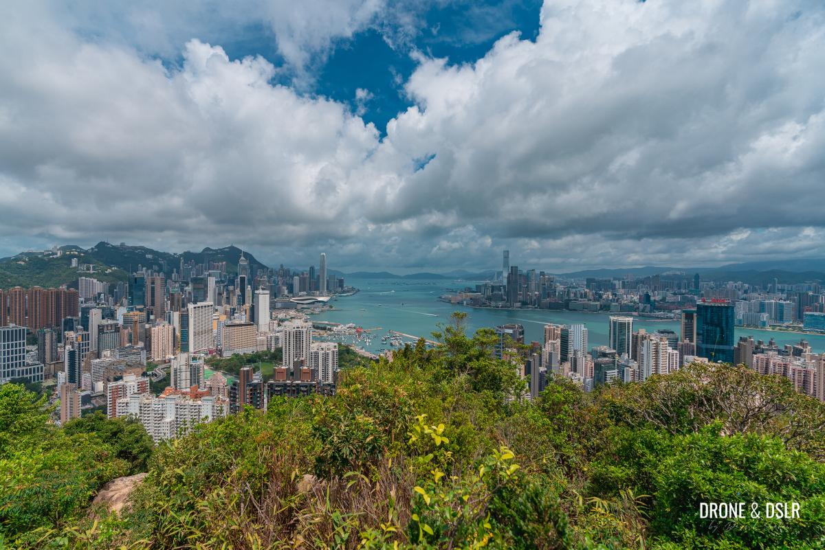
Photo by Drone & DSLR
MTR to trailhead: about 20 to 30 minutes | Difficulty: Easy to Moderate
Braemar Hill — properly known as Red Incense Burner Hill — rises behind the Tin Hau and North Point neighbourhoods on the north shore of Hong Kong Island. It is one of the least-hyped trails on the island and one of the most rewarding for early morning walks. The view from the summit looks north across the harbour, over Kowloon, and on clear days to Lion Rock in the distance. The trail is shaded, well maintained, and almost never crowded.
Exact directions — Route 1 (walking from Tin Hau): Take the Island Line to Tin Hau MTR, Exit A. Walk east along Tung Lo Wan Road for about 3 minutes, then turn left onto Electric Road. Continue uphill along Electric Road as it curves north — the road becomes Braemar Hill Road. The Country Park entrance is approximately a 20 minute walk from the MTR exit. The path into the country park begins at the barrier on Braemar Hill Road. This walking approach is pleasant through the residential streets and adds to the sense of leaving the city behind.
Exact directions — Route 2 (bus from North Point): Take the Island Line to North Point MTR, Exit A. At the bus stop on King's Road, board bus 25 (destination: Tai Hang Road). Ride for approximately 10 minutes and alight at the Braemar Hill Road stop. The Country Park entrance is a short walk uphill from the bus stop.
Return: retrace your route, or descend the eastern side of the hill toward Quarry Bay MTR — a longer descent through residential streets that changes the walk pleasantly.
4. Sunset Peak (Yi Tung Shan) — Tung Chung MTR
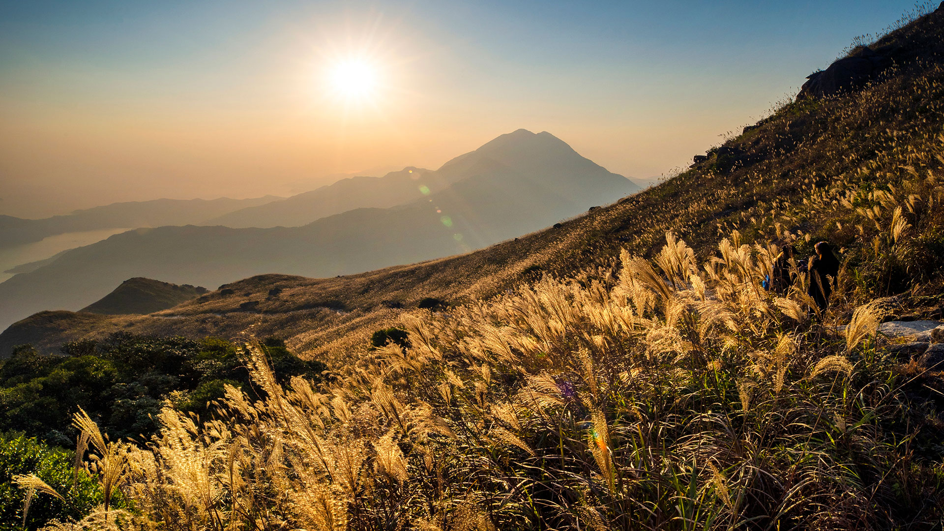
Photo by Little steps Asia
MTR to trailhead: about 35 to 40 minutes | Difficulty: Strenuous
Sunset Peak stands at 869 metres — the third highest point in Hong Kong — on southern Lantau Island. The trail traverses open moorland on the upper ridge, passing through the Lantau Trail's highest section. The views from the summit are exceptional in every direction: the South China Sea to the south, Lantau's interior valleys below, and on clear days the Pearl River delta stretching west. It is a serious hike that rewards serious preparation.
Exact directions: Take the Tung Chung Line to Tung Chung MTR, Exit B. From the exit, cross the open plaza toward the bus terminus, which is clearly signed. Board New Lantao Bus 11 (destination: Mui Wo via South Lantau Road) from the Tung Chung Bus Terminus. This bus climbs into the Lantau hills — ride to the stop at Pak Kung Au (the mountain pass between Tung Chung and Cheung Sha). The journey takes approximately 25 to 30 minutes. At Pak Kung Au, there is a small shelter and a signed junction: the Lantau Trail heads uphill from the roadside. Sunset Peak is approximately 1.5 to 2 hours of climbing from this junction.
Confirm the bus stop with the driver when boarding — say "Pak Kung Au" — as the route does not always display individual stop names on the on-board display. If you overshoot, you will be in Cheung Sha, which requires a taxi back to the pass.
Return: descend the same route to Pak Kung Au and catch bus 11 back to Tung Chung, or continue the Lantau Trail to Mui Wo and take the ferry to Central (about 55 minutes, much more scenic).
5. Kam Shan Country Park Trail — Kowloon Tong MTR

Photo by iStock
Kam Shan Country Park is the green wedge that sits between Kowloon and the New Territories, and it is the most accessible country park in the territory relative to the urban density around it. The main trail follows the Kowloon Reservoir circuit through mixed woodland, past secondary forest that has recovered quietly since the 1970s. The macaques are a fixture — treat them as wildlife, not entertainment, and keep food inside your bag.
Exact directions: Take any MTR line to Kowloon Tong station, Exit D. Walk north along Junction Road for approximately 15 minutes until you reach Shek Lei Pui Reservoir Road on your left. Alternatively, from the exit board bus 81 toward Tsuen Wan and alight at the Kam Shan Road stop — approximately 10 minutes. From Kam Shan Road, the country park entrance and the main reservoir circuit trailhead are clearly marked.
The reservoir circuit takes about 1.5 to 2 hours at an easy pace. For a longer walk, the trail connects north toward Tai Po Road and the Tai Mo Shan Country Park boundary.
Read more in our guide to summer hiking in Hong Kong, where Kam Shan features as one of the best warm weather options.
6. Sai Kung Eastern Country Park Trails — Hang Hau or Diamond Hill MTR

Photo by AllTrails
MTR to trailhead: about 30 to 40 minutes | Difficulty: Varies
Sai Kung is a collection of trails rather than a single walk — the eastern country park contains some of the most varied terrain in Hong Kong, from MacLehose Stage 2 (the Sai Wan to Ham Tin coastal route) to the gentler shores around High Island Reservoir. Getting there from the MTR is two-stage but straightforward.
Exact directions — via Hang Hau MTR: Take the Tseung Kwan O Line to Hang Hau MTR, Exit B1. From the exit bus terminus, board green minibus 101M (destination: Sai Kung Town). The minibus runs frequently and takes approximately 20 minutes to Sai Kung town centre. From Sai Kung town you are close to multiple trailheads. For MacLehose Trail Stage 2 (Sai Wan to Ham Tin), take a taxi from Sai Kung to Sai Wan Pavilion — about HKD 80 to 100, 20 minutes. It is not accessible by public bus.
Exact directions — via Diamond Hill MTR: Take any MTR line to Diamond Hill station, Exit C2. At the nearby bus stops on Lung Poon Street, board KMB bus 92 (destination: Sai Kung). The bus runs frequently and takes approximately 40 minutes to Sai Kung town, passing through Clearwater Bay Road. From Sai Kung the same onward options apply as above.
The Diamond Hill route is useful if you are connecting from Kowloon; Hang Hau is faster if you are coming from the east.
Our dedicated guide to Sai Wan and Ham Tin covers this trail in full.
A Few Things Worth Knowing Before You Go
Bus and minibus schedules in Hong Kong are reliable on the main routes but can change seasonally. Always check the KMB website or the MTR journey planner for current timetables before you leave. For rural routes (like bus 9 to Shek O or bus 11 to Pak Kung Au), the last service of the day can be earlier than you expect — know your return time before you start walking.
The Hong Kong Observatory weather app is worth having. Hong Kong weather is dramatic and localized — clear skies in Kowloon and a storm over the Lantau ridgeline are not unusual in the same afternoon.
Typhoon rules apply to all of these trails. At T3 or above, hiking is not safe. At T8 or above, the MTR also reduces service. Check the signal before you leave and have a backup plan in summer.
All six trails in this guide appear in Iconic Hikes Hong Kong — the book that treats Hong Kong's natural landscape with the same seriousness as its urban identity.
→ Get the book. → Browse all trail prints.Hong Kong Hikes Near MTR: Common Questions
Which Hong Kong hike has the easiest MTR access?
Braemar Hill (Red Incense Burner Hill) is walkable directly from Tin Hau MTR without any connecting bus — about 20 minutes on foot from the exit to the country park entrance. Kam Shan Country Park is similarly close to Kowloon Tong station. Both are suitable for anyone who prefers to avoid bus logistics entirely.
Do I need an Octopus card for the buses?
Yes — KMB buses and most green minibuses in Hong Kong accept Octopus for payment. Some rural minibuses are exact change only if paying by cash. An Octopus card is worth having regardless; it works on the MTR, all buses, most ferries, and many convenience stores. Top it up at any MTR customer service centre or at add-value machines inside stations.
Can I do Dragon's Back on a weekday?
Yes, and weekdays are preferable. Bus 9 runs on a regular schedule throughout the week. The trail is significantly quieter from Monday to Friday, and Shek O village (the natural endpoint) is more relaxed without the weekend crowds.
Which of these hikes is best for the views?
Sunset Peak offers the most expansive views — open moorland ridge with 360 degrees of visibility. Dragon's Back is the best combination of views and accessibility. Lion Rock gives the most iconic urban panorama: the entire Kowloon basin spread below you. Each is different in character and each is worth doing.
Is there a comprehensive map of these hikes?
The AFCD country parks hiking map covers all country park trails in Hong Kong. For navigation on the trail, AllTrails has GPX tracks for most of these routes. For understanding the trails as cultural objects — what they mean and why they matter — that is what Iconic Hikes Hong Kong is for.
More from UpKow
- The complete guide to hiking in Hong Kong
- The best hikes in Hong Kong
- Easy hikes in Hong Kong for beginners
- Dragon's Back: Hong Kong's most iconic coastal trail
- How to get to the Peak, Hong Kong — every option explained
- 5 must-do hikes in Hong Kong: a 5 day itinerary
- The best Hong Kong gifts for hikers
- 9 things that surprise first time hikers in Hong Kong
- 5 Hong Kong hikes you can finish before breakfast
- Summer hiking in Hong Kong: trails, timing, and typhoon rules
- Lion Rock Hong Kong: the trail behind the symbol
- The best waterfall hikes in Hong Kong
- Dragon's Back vs The Peak: which Hong Kong trail should you do?
- Bride's Pool: the Hong Kong trail where the city becomes a rainforest